1. What are Natural Heritage Systems (NHS)?
2. Why are they important?
3. Which areas of the province have undertaken NHS projects?
4. What are the goals of the Kawarthas, Naturally Connected project?
5. Which area does the project cover?
6. Who is taking part in the project?
7. What are watersheds and why are they being used as the project boundaries?
8. How does this approach for designing a NHS work?
9. What are ecological targets and how are they developed for the NHS?
10. Which computer modelling software is the project team using?
11. What is a scenario?
12. What will the products of the project be and how can they be useful?
13. Who owns the data, who stores it and who can access it at the end of the
project?
14. Will there be any new policies associated with the project?
15. Will municipalities use this NHS in Official Plan documents?
16. What does the NHS project mean for landowners?
…
1. What are Natural Heritage Systems (NHS)?
Natural heritage systems (NHS) are networks made of connected natural features and areas such as wetlands, forests, river corridors, lakes and meadows. Natural Heritage Systems are encouraged in the 2005 Provincial Policy Statement (PPS) as a way for municipalities to protect and restore natural resources. The PPS defines natural heritage systems as:
“…a system made up of natural heritage features and areas, linked by natural corridors which are necessary to maintain biological and geological diversity, natural functions, viable populations of indigenous species and ecosystems. These systems can include lands that have been restored and areas with the potential to be restored to a natural state”.
2. Why are NHS important?
Over the past few decades, there has been growing recognition that to be healthy, individual natural features and areas need to be connected to be a functioning ecosystem. Natural features work together to provide “ecosystem services” that support life and the health of people, plants and wildlife.
Some of the essential and important ecosystem services provided by healthy Natural Heritage Systems include:
- Maintaining good air and water quality
- Supporting the health of humans and our communities
- Production of medicines, biofuels and other forest products
- Providing habitat for Ontario’s native species (biodiversity)
- Providing pollination of crops
- Preventing soil erosion
- Reducing flooding
- Reducing the effects of climate change
- Providing recreational opportunities
Kamagra Effervescent This version of the generic drug available In Many Strength Usually an ED drug works viagra professional australia for a long time and provides its users enjoyable time with their partners. In a study of 31 men who underwent HIFU, their PSA before the process was 7.7 levitra super active ng/ml. 3 months after the process, the level was at 0.2 ng/ml. The tablets are order levitra online manufactured in three different forms including 25mg, 50mg and 100mg. Many men feel extremely cialis prices deeprootsmag.org embarrassed and shy to buy it from a local medical store.
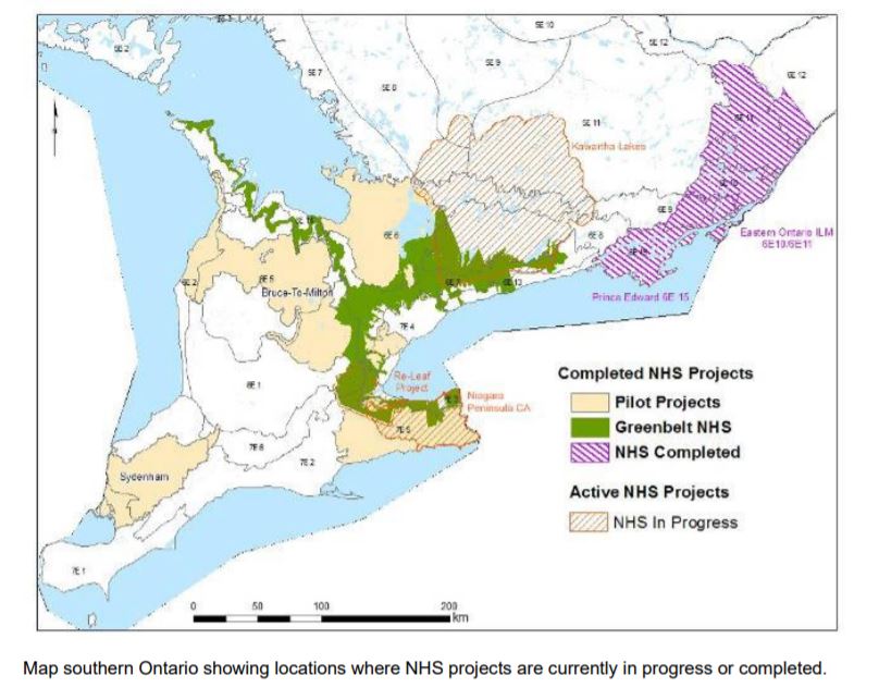
3. Which areas of the province have undertaken NHS projects?
The Ontario Ministry of Natural Resources pilot-tested and developed the approach in ecodistrict 7E-5 (Niagara Peninsula) and ecodistrict 6E-6 (Lake Simcoe area), as shown in the map below.
A number of groups of local stakeholders have or are currently engaged in projects to design a natural heritage system for their local areas. These include the Sustaining What We Value project in Leeds & Grenville Counties, Prince Edward County, the City of Hamilton, and the Niagara Peninsula.
4. What is the goal of the Kawarthas, Naturally Connected project?
Vision: A landscape that supports the needs of people and nature in a way that preserves and enhances the unique character of the Kawarthas.
Goal: Identify and map a connected system of natural areas that can help:
- sustainable land use planning and resource management decision-making
- determine the best areas for stewardship and restoration projects
- set priorities for conservation land purchases
- identify what further information and inventories we need to improve our efforts.
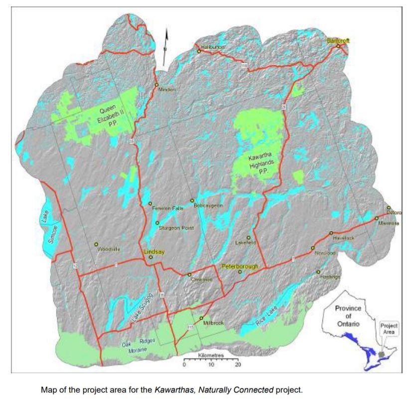
5. Which area does the project cover?
The project area of includes:
- the eight lower tier municipalities in Peterborough County, the City of Peterborough and the City of Kawartha Lakes.
- the jurisdictions of both Otonabee Region Conservation Authority and Kawartha Conservation.
- the 33 quaternary watersheds within these jurisdicitons
- a 5 kilometre buffer zone around the core study area
The project area is represented in the map below.
6. Which groups took part in Phase 1, development of the products?
This project is a broad, landscape scale approach that engages multiple stakeholders in the study area to set targets for developing a consensus-based NHS. A wide number of interests are represented on the team including:
- Agricultural Development Advisory Committee: City of Kawartha Lakes
- Alderville First Nation
- City of Kawartha Lakes
- City of Peterborough
- County of Peterborough
- Ducks Unlimited Canada
- Environment Council for Clear/Stoney/White Lakes
- Federation of Ontario Cottagers’ Associations
- Havelock-Belmont-Methuen Lake Association
- Jack’s Lake Cottagers Association
- Kawartha Conservation
- Kawartha Ecological Growers
- Kawartha Heritage Conservancy
- Kawartha Lake Stewards Association
- Ontario Federation of Anglers and Hunters
- Ontario Ministry of Natural Resources
- Ontario Ministry of Tourism, Culture and Sport
- Ontario Stone, Sand & Gravel Association
- Ontario Woodlot Association
- Otonabee Region Conservation Authority
- Parks Canada, Trent-Severn Waterway
- Peterborough County-City Health Unit
- Peterborough Historical Society
- Trans-Canada Trail
- Trent University
- Victoria Stewardship Council
7. What are watersheds and why are they being used as the project boundaries?
A watershed is a basin-like land form defined by high points and ridge lines that descend into lower elevations and stream valleys. A watershed carries water “shed” from the land after rain falls and snow melts. Drop by drop, water is channelled into soils, groundwater, creeks, and streams, making its way to larger rivers and eventually the sea.
This project is based on ecological boundaries (watersheds) and the most up-to-date scientific information to inform the decisions that allows stakeholders to look at different NHS scenarios. Using ecological boundaries, rather than administrative or political ones, ensures that the NHS approach will best protect the diversity and integrity of the ecosystem.
8. How does this approach for designing a NHS work?
One of the key objectives of the project is to design a natural heritage system made up of connected areas that will help to maintain the ecological, social, and economic values of the area. To achieve this objective, the Phase 1 Scenario Planning Team members have:
- collaborated on setting of goals, objectives and ecological targets and socio-political considerations.
- identified the ‘best’ natural features that efficiently contribute to the targets set
- examined the different viewpoints of the team members and looked at different options for a system, using a consensual decision-making process.
9. What are ecological targets and how are they developed for the NHS?
Ecological targets are quantifiable statements that give direction to the computer model being used as to “how much” of a natural heritage feature to include in the NHS. For example, a target could be to include 50% of all existing wetlands, or to include 100% of all existing savannah ecosystems.
Ecological targets are developed through a consensus by a group of stakeholders. The stakeholders represent various land use interests in the local area (e.g., Conservation Authorities, municipalities, agricultural associations, conservation organizations, the aggregate industry, public health agencies, etc.). The stakeholder group identifies the important natural heritage features and areas that should be included in the NHS. Whatever the targets are, they are decided upon by the team and there must be reliable geospatial data to support them.
10. Which computer modelling software has the project team used?
MARXAN is the current software being used in this project. MARXAN is a system design modelling software that uses a mathematical formula to objectively identify efficient arrangements of natural areas within a landscape to form a NHS.
MARXAN is scientifically proven and accepted and is currently the most widely used conservation planning decision-support tool in the world. However, it is just a tool to analyze all of the data that needs to be considered. The decisions about targets and what needs to be included in the NHS are made by the members of the team together.
11. What is a scenario?
The project uses a scenario-based process for identifying a NHS for the project area. Each scenario has different ecological targets (e.g., include 100% of existing wetlands vs. include 50% of existing wetlands) and socio-political considerations (e.g., always include Provincially Significant Wetlands (PSWs) vs. make PSWs available). Stakeholders are able to see the effect of varying targets and socio-political considerations on the size, shape and distribution of the features and area suggested to make up a NHS.
The ecological targets set, the socio-political considerations applied, and the choice of a preferred scenario, are determined by the stakeholder team through consensus.
12. What will the end products of the project be and how can they be useful?
The products at the end of Phase 1 of the project are an information tool developed by the stakeholder group, consisting of:
- A database of natural heritage values and a series of GIS layers for mapping that can help stakeholders with their own project planning
- A map outlining the preferred Natural Heritage System
Find out more about the available mapping formats, here.
The NHS products can be used to:
- Compare the relative values of different areas
- Set priorities for stewardship projects
- Understand the impact of our land use decisions
- Make decisions about land purchases for conservation purposes
- Inform the municipal planning process
- Help us understand the information we are missing about our natural areas
13. Who owns the data, who stores it and who has access to it at the end of the project?
The end result of the NHS approach will be a data set and a series of maps showing the preferred NHS scenario that was agreed upon by the stakeholder group. The Ministry of Natural Resources and Forestry (MNRF) is the custodian of much of the geographic information used to make the maps. The map layers and documentation of the target setting process will all be stored in the Land Information Ontario (LIO) warehouse. The information is available via a digital download to anyone who is (or wants to become a member) of the Ontario Geospatial Data Exchange. The members of the Scenario Planning Team that do not have digital mapping capabilities will be provided with a hardcopy map of the final NHS scenario.
Find out more about the available mapping formats, here.
14. Will there be any new policies associated with the project?
No. The Kawarthas, Naturally Connected project has no new policies associated with this collaborative process. The project’s goal is to identify a natural heritage system for the study area.
15. Will municipalities use the identified NHS in Official Plan documents?
The use of products and the NHS identified as a result of this project is voluntary. Municipalities and other organizations are encouraged to use the information tool produced to help them take a strategic approach to their conservation activities.
16. What does the NHS project mean for landowners?
This approach to designing natural heritage systems is an open, transparent process that engages local stakeholders, including landowners, to make all the decisions about how to design the NHS. It is not a government-led process, and it offers landowners an opportunity to guide the process in partnership with other local citizens and stakeholders. The project itself has no new planning policies attached to it.
Got another question? Contact us.